Early Wildfire Detection in Brazil: 95% Recall and Under-5-Minute Alerts
10 min readUpdated October 9, 2026
Omdena
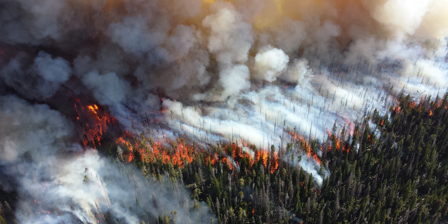
Brazil’s forests and farmland lose millions of acres annually to wildfire, with the Pantanal recording a 462% surge in fire events in one year alone. Omdena partnered with Sintecsys, a Brazilian fire monitoring company, to build a CNN-based smoke detection system covering 8.7 million acres across 50 tower-mounted cameras. The 8-week project delivered models achieving 95–97% recall, an 8,750-image labeled dataset, and a reduction in average detection time from 40 minutes to under five minutes.
Watch the Webinar
See how AI can help detect wildfires earlier and support faster, more informed response.
In this webinar, we explore the computer vision approach, AI models, and key challenges behind the project, along with its results and practical applications for earlier wildfire detection and faster response.
Outcome
Detail
Smoke detection recall
95–97% on daytime images
False positive rate
10–33% (fog, dust, cloud, glare filtered)
Detection time
Reduced from 40 minutes to under 5 minutes
Training dataset
~8,750 labeled images from client camera network
Crop and tree loss
90% reduction in reported losses
Project team
47 collaborators from 22 countries, 8 weeks
The Problem: Wildfire Detection at Scale Across Brazil’s Forests and Farmland
Wildfires are a recurring crisis in Brazil. In 2020 alone, over 8,000 fires were recorded in the Pantanal, marking a 462% increase over the prior year. Globally, wildfires contribute one-third of total CO₂ emissions, damaging ecosystems, harming respiratory health for communities downwind, and generating significant financial losses for agricultural companies.
The client monitored 8.7 million acres of Brazilian forest and farmland using 360-degree cameras across seven states and four biomes. Operators reviewed live feeds around the clock, manually verifying each alert before dispatching firefighters. By 2019, average detection time stood at 40 minutes, long enough for a small fire to become uncontrollable.
The Partnership: Omdena and Sintecsys
Founded in 2016, the client operates a real-time fire outbreak detection and land management platform serving agricultural companies, forest owners, and municipal authorities across Brazil. Its monitoring system uses 360-degree cameras on 50 communication towers and transmits live imagery to a central facility, where operators watch for the first signs of smoke around the clock.
Omdena partnered with the client to build an AI wildfire detection system using computer vision and deep learning. Over eight weeks, 47 collaborators from 22 countries worked alongside the client’s internal AI team to design, train, and evaluate models capable of detecting smoke in daytime imagery with high accuracy and low false positive rates.
Why Early Wildfire Detection Is Hard: Visual Noise, Missing Data, and Changing Light
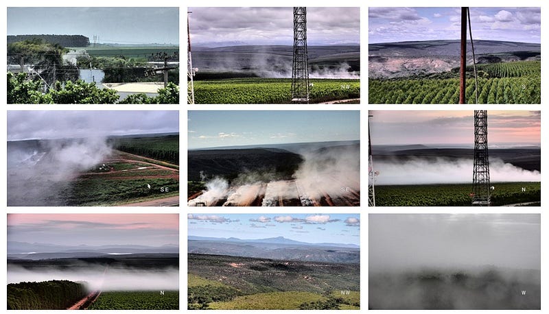
Visual ambiguity at distance: Smoke in a camera feed is nearly indistinguishable from fog, low cloud cover, dust kicked up by vehicles or wind, and emissions from agricultural equipment. Any model trained to catch smoke aggressively will also flag these look-alikes; any model tuned to suppress false alarms risks missing the first sign of a real fire.
No existing labeled dataset: No open, labeled wildfire dataset existed matching the resolution, camera angle, and conditions of the client’s tower network. Every training image had to be extracted from the client’s own footage and manually annotated — a substantial pre-training workload before model development could begin.
Boundary lighting conditions: Sunrises, sunsets, and shifting weather patterns alter how smoke appears against the sky, creating conditions where even consistent image quality does not guarantee stable model performance. Separating genuine smoke from sky color changes at dawn and dusk required careful attention during both labeling and data augmentation.
Building the Detection System: Dataset Curation, CNN Architectures, and Parallel Experimentation
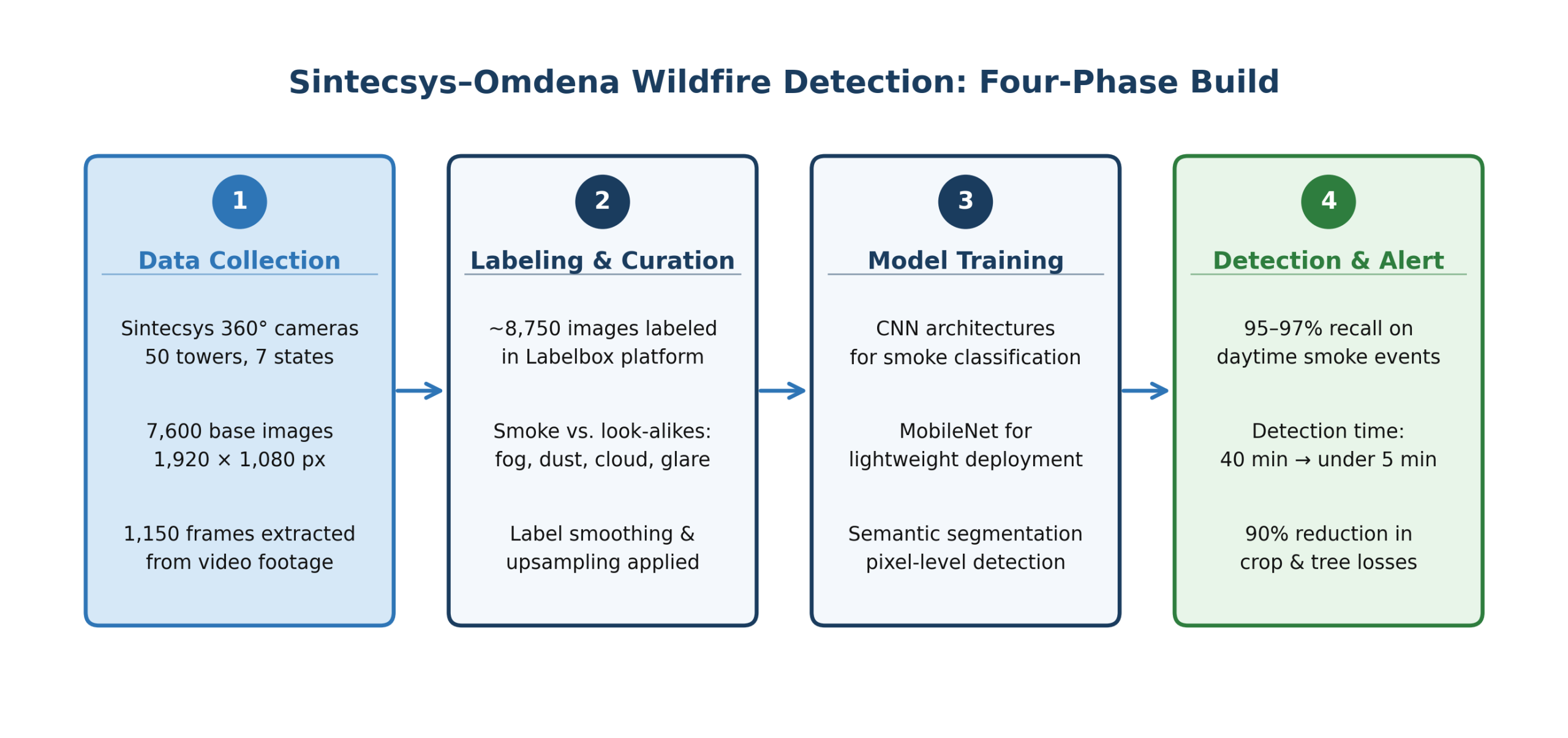
Four-phase build: data collection, labeling and curation, model training, and detection and alert. Source: Omdena
Step 1 — Data Collection
The team assembled a training corpus of approximately 8,750 images from the client’s camera network, covering fire and non-fire scenes across different times of day. Gary Diana developed an algorithm to extract frames from video footage without generating duplicates, adding 1,150 frames at 1,280 × 720 pixels to the initial 7,600-image base.
Step 2 — Labeling and Curation
Labeling was handled by approximately 20 volunteers using Labelbox, which enforced role separation between labelers, reviewers, team managers, and administrators. This structure prevented contributors from overwriting one another’s work and enabled consistent quality control across a corpus mixing genuine smoke events with fog, dust, cloud, and glare.
Sample images from the client’s 360-degree camera network used to train the smoke detection model.
To improve generalization, the team applied horizontal and vertical flips, image patches of varying sizes, and upsampling for lower-resolution frames. Label smoothing helped models distinguish genuine smoke from boiler emissions and lens flare.
Step 3 — Model Architecture Exploration
Three parallel tracks ran simultaneously: MobileNet architectures for edge deployment on lower-powered hardware; semantic segmentation to localize smoke at the pixel level; and CNN classifiers ranging from simple binary models to deep feature extraction networks. CNN-based classifiers produced the highest recall on the client’s held-out test images and were selected as the foundation for the deployable system.
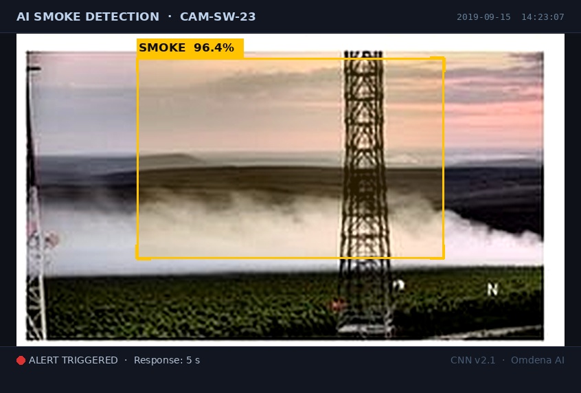
CNN output: smoke detected at 96.4% confidence — alert within 5 seconds.
What Was Delivered: A Deployable Daytime Smoke Detection Model and Training Pipeline
CNN-based smoke detection model: A trained convolutional neural network that analyzed daytime camera images in real time, flagging frames containing smoke and suppressing alerts for common look-alikes. Initially deployed as a prototype with one client, the model integrated with the existing monitoring platform without requiring new hardware; full rollout to all customers was planned for end-2020.
Labeled training dataset of 8,750 images: A curated corpus drawn from the client’s own camera network, covering fire and non-fire scenes across multiple biomes and lighting conditions. The dataset included smoke, fog, dust, cloud, and glare examples, enabling the model to learn the differences between genuine outbreaks and visual noise at scale.
Full open-source training pipeline: The complete preprocessing, augmentation, and training workflow was delivered as open-source code through OmdenaLore. The client retained the ability to retrain on new footage and extend the system to nighttime detection in a planned second phase.
Impact: Faster Detection and Fewer False Alarms Across 8.7 Million Acres
The model achieved 95–97% recall on held-out daytime test images, identifying nearly every genuine fire event in the evaluation set. Average detection time dropped from 40 minutes to under five minutes, and the client reported a 90% reduction in crop and tree losses across monitored territories.
Before the AI layer, operators reviewed every alert including false triggers from fog, clouds, and dust. The false positive rate varied between 10% and 33% depending on camera location — forest towers produced fewer spurious alerts than cameras near agricultural equipment and road traffic. With the model handling initial classification, operators focused on events already screened as likely genuine.
Fewer uncontrolled burns meant less CO₂ released from Brazil’s biomes. Faster detection also reduced smoke exposure for farming communities near monitored land, where respiratory illness linked to wildfire smoke is a documented public health concern.
Benefits for Clients: Automated Monitoring Without New Infrastructure
Automated first-pass filtering on existing camera streams: The model processed every incoming camera frame before it reached a human screen, eliminating manual review of fog, dust, and cloud events. Operators received fewer alerts and focused on events the model had already flagged as likely genuine.
No specialist AI skills required to operate: The client’s monitoring staff continued their established review workflow unchanged. The AI layer slotted in as a pre-filter, with no retraining of personnel, no changes to team structure, and no new tools to learn.
Open-source training pipeline via OmdenaLore: The full dataset, model weights, and training code were delivered as open-source assets through OmdenaLore. The client retained the ability to retrain on new data and scale to additional camera networks without licensing constraints or vendor dependency.
What Building a Wildfire Detection System for Brazilian Forests Taught Us
A model optimized for recall outperforms a precision-focused model in fire monitoring contexts
The team prioritized recall and accepted a 10–33% false positive rate as a deliberate trade-off. A missed fire carried far greater cost than a false alarm cleared by an operator in seconds — a priority that shaped every architecture decision and confidence threshold tested.
Label quality determines model quality more than architecture choice in computer vision projects of this scale
Assembling and labeling approximately 8,750 images required more effort than training the models themselves. The Labelbox workflow and role separation made the corpus reliable — switching architectures cannot compensate for noise introduced at the annotation stage.
Defining a narrow first-phase scope is what makes a complex system deployable on time
Limiting Phase 1 to daytime smoke detection allowed the team to deliver within 8 weeks. Nighttime detection, satellite integration, and predictive risk mapping were real requirements — scoping them as later phases, rather than attempting all conditions in parallel, was what made the initial deployment achievable.
What’s Next: Nighttime Detection, Satellite Integration, and Predictive Risk Mapping
Nighttime flame detection (Phase 2): Flames at night appear as bright point sources against dark backgrounds — a fundamentally different visual signature from daytime smoke, requiring separate labeled data and adapted model architectures. Integrating day and nighttime detection will give the platform consistent capability around the clock.
Satellite imagery integration: Ground-level towers leave coverage gaps between their fields of view. Satellite feeds will supply continuous spatial coverage, identifying smoke plumes or thermal signatures in uncovered areas and routing alerts into the same monitoring dashboard operators already use.
Predictive risk mapping: More than 90% of Brazilian wildfires are linked to human activity. The client plans to develop AI tools that identify elevated-risk areas before smoke appears, using historical fire records, land-use patterns, and human activity data to concentrate monitoring where fires are most likely to ignite.
Key Achievements: Detection Performance, Response Time, and a Reusable Data Asset
A Smoke Detection Model That Catches Nearly Every Fire Event
The model’s 95–97% recall meant nearly every fire event in the test set was identified at the earliest visible stage, giving firefighting teams time to intervene before flames spread — a response window the previous 40-minute baseline made impossible.
An 87% Reduction in Average Detection Time Across 8.7 Million Acres
The 35-minute reduction in alert time changed what a monitoring team can do. A fire caught within five minutes burns a fraction of the area lost at the 40-minute mark. The 90% reduction in crop and tree losses across monitored territories reflects that operational difference.
A Labeled Dataset Built from Production Camera Footage
Generic wildfire datasets do not reflect the specific camera angles, lighting conditions, and vegetation types of any one system. The 8,750-image corpus gives the client a foundation to extend for Phase 2 nighttime training without restarting data collection and annotation from scratch.
About the Project
Omdena partnered with Sintecsys, a Brazilian fire monitoring company, to build an AI wildfire detection system using computer vision and deep learning. Over eight weeks, 47 collaborators from 22 countries assembled and labeled 8,750 images, trained CNN-based smoke detection models, and delivered a system achieving 95–97% recall that reduced detection time from 40 minutes to under five minutes.
FAQ
Why did the team focus on daytime images first?
Daytime images show smoke clearly, making them the most reliable training target. Nighttime detection — where flames rather than smoke are the primary signal — was scoped as Phase 2.
How does the model distinguish smoke from fog or clouds?
Label smoothing taught the model to separate genuine smoke from fog, dust, cloud shadows, and boiler exhaust. Data augmentation across varied lighting helped it generalize across the client's full camera network.
What accuracy did the model achieve?
The model achieved 95–97% recall on daytime images with a false positive rate of 10–33%. The team deliberately prioritized catching every real fire over minimizing alerts, which operators could clear in seconds.
Can this approach be used outside Brazil?
The CNN architecture is not geography-specific, but redeployment requires new labeled images reflecting local vegetation and lighting conditions. The open-source training pipeline via OmdenaLore supports retraining without rebuilding from scratch.
Share this article
Share on LinkedIn, send by email, or copy the direct link.