Climate-Driven Displacement in Somalia: Early Warning Across Drought, Flood, and Conflict
12 min readUpdated November 9, 2026
Omdena
Displacement in Somalia is predictable weeks before it peaks, yet no early warning system existed for the humanitarian agencies managing shelter and food across the country’s most vulnerable provinces. Omdena partnered with the UN Refugee Agency to build satellite anomaly detection and a neural network forecasting weekly vegetation conditions from 40 years of NOAA records. Delivered: province-level early warning forecasts, 99% conflict zone monitoring accuracy, and an open-source codebase.
Key Outcomes
Outcome
Detail
Early warning capability
One-week ahead VHI forecast per Somali province, enabling pre-positioning before displacement peaks
Classifier accuracy
99% in holdout evaluation: Random Forest for Landsat 8 land cover changes; SVM for armed conflict event zones
Neural network validation loss
0.030 — province-level VHI prediction trained on 40 years of NOAA/NESDIS weekly records
Satellite pipeline
Unsupervised PCA + K-Means change detection; no labeled training data required
NOAA/NESDIS VHI weekly since 1984; Landsat 8 and MODIS imagery; UNHCR displacement records 2016–2019
Team
34 AI experts and data scientists
The Problem: Predicting Forced Displacement Before It Peaks in Somalia
Somalia is one of the most displacement-intensive countries in the world. More than 2.6 million people are internally displaced at any given time, moving in response to three overlapping hazards: prolonged drought, sudden flooding, and armed conflict.
Each hazard demands a different humanitarian response, requires different pre-positioning of food, shelter, and medical supplies, and unfolds on a different timescale. By the time displacement events appeared in field reports, the acute phase of the crisis had already passed.
The UN Refugee Agency tracked weekly displacement figures by province from January 2016 through mid-2019, capturing arrivals, departures, and stated departure reasons. Drought was the most commonly cited reason across the dataset, though conflict and flooding dominated in specific provinces.
Those records were reactive, not predictive. No mechanism connected climate deterioration — a falling Vegetation Health Index, a detected flood event, a vegetation anomaly in satellite imagery — to anticipated population movement in a given province. The humanitarian response was always catch-up rather than preparation.
The Partnership: Omdena and the UN Refugee Agency
In 2019, the UN Refugee Agency commissioned Omdena to build a predictive intelligence system for Somalia. The challenge required linking satellite-derived climate signals to displacement patterns, a data integration problem crossing geospatial science, time-series forecasting, and humanitarian operations. A team of 34 AI experts and data scientists assembled on the Omdena platform over the project period.
The client supplied historical weekly displacement records segmented by Somali province, including counts of arrivals, departures, and stated reasons for movement. Omdena sourced satellite imagery from NASA’s EarthExplorer platform using Landsat and MODIS sensors, and vegetation health data from NOAA’s STAR/NESDIS archive, with records extending back to 1984.
Why Climate-Displacement Forecasting Is Hard
Three overlapping hazard types: Drought, floods, and armed conflict drive displacement through entirely different causal pathways and at different speeds. A model trained on drought-displacement dynamics may miss flood-driven events entirely, and conflict displacement often carries no climate signal at all. Separate modeling approaches were required for each hazard type rather than a single unified predictor.
High-volume satellite data with limited labels: MODIS satellite scenes for Somalia run to roughly 1 GB per image across 13 spectral bands. Processing these at scale required dimensionality reduction before any clustering or classification was viable. The team first attempted a CNN+LSTM deep learning architecture but found insufficient labeled training data to achieve stable results on Somalia’s historical satellite record.
Lag effects between climate signals and displacement: A drop in the Vegetation Health Index does not immediately cause displacement. Populations endure deteriorating conditions for days or weeks before departing. Time-series modeling must account for this lag, correlating a VHI reading with displacement counts from one or more weeks later, a gap that varies by province and hazard type and must be established empirically.
Weekly aggregation limits spatial granularity: Both the UNHCR displacement records and the NOAA VHI data arrived as weekly aggregates at the province level. No sub-provincial or daily granularity was available, constraining the spatial and temporal precision of any displacement forecast to the province as the smallest actionable unit.
Building the Somalia Early Warning System: Satellite Anomaly Detection and Neural Network Forecasting
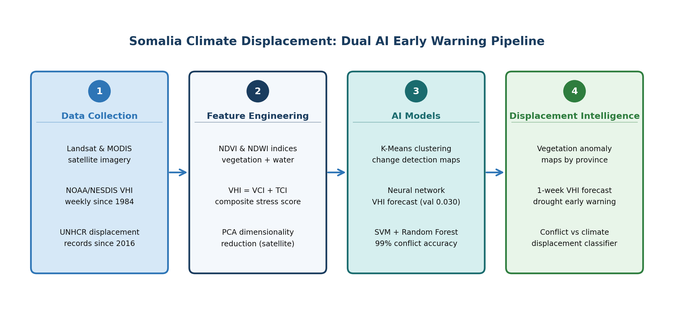
Somalia Climate Displacement: Dual AI Early Warning Pipeline: data collection, feature engineering, AI models, and displacement intelligence outputs. Image Source: Omdena
Vegetation Anomaly Detection via Satellite Imagery
The first workstream processed Landsat and MODIS satellite scenes to detect sudden changes in vegetation cover, a leading indicator of drought onset or flood damage. Computing pixel-level difference images and extracting NDVI (Normalized Difference Vegetation Index) and NDWI (Normalized Difference Water Index) channels, the team then applied Principal Component Analysis to compress the high-dimensional pixel data into a tractable feature set for clustering.
K-Means clustering with two clusters (changed and unchanged) then labeled each pixel in the difference image. The result was a change detection map showing regions where vegetation health had shifted significantly between observation windows. Areas of sudden vegetation loss flagged potential drought zones; sudden increases following precipitation events identified flood-affected areas.
Neural Network VHI Forecasting
The second workstream built a time-series predictor for the Vegetation Health Index (VHI), a composite indicator of climate stress. VHI combines VCI (Vegetation Condition Index, measuring greenness relative to historical norms) and TCI (Thermal Condition Index, measuring temperature stress). Readings below 15 indicate severe drought; below 35, moderate; above 65, good; above 85, very good, published weekly by NOAA’s STAR/NESDIS for each Somali province.
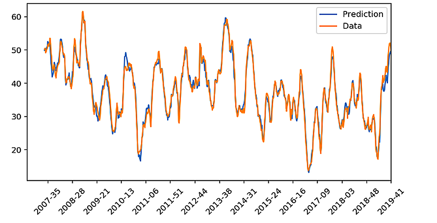
The team trained a neural network on weekly VHI records for each Somali province, stretching back to 1984. The model learned to predict the following week’s VHI from recent historical sequences, achieving a validation loss of 0.030 against a training loss of 0.005. Those forecasts gave the client a one-week forward view of vegetation stress before displacement pressure built in the most climate-sensitive provinces.
Neural network prediction (blue) versus actual weekly VHI values (orange) for a Somali province, 2007–2019. Validation loss: 0.030. Image Source: Omdena
Two classifier workstreams ran alongside the main pipeline. A Random Forest model applied to Landsat 8 imagery of the Banadir region, Somalia’s largest displacement destination, classified land cover changes at 99% accuracy, showing how conflict and population movement reshaped the urban environment between observation windows.
An SVM classifier trained on armed conflict event records identified high-fatality violence zones by location and incident type, also reaching 99% accuracy. Together, the two classifiers let the client distinguish regions where displacement pressure was environmentally driven from those where conflict was the primary force.
What Was Delivered: Climate Intelligence Reports for Somalia
Satellite change detection pipeline: An unsupervised pipeline that ingests Landsat and MODIS scenes, computes pixel-level difference images, applies PCA dimensionality reduction, and outputs change maps via K-Means clustering. The pipeline runs without labeled training data, making it immediately applicable to provinces with limited historical annotation.
Neural network VHI forecaster: A trained model predicting weekly Vegetation Health Index by province, one week ahead. With a validation loss of 0.030, the forecast feed provided the client with early indicators of climate deterioration before displacement began, a capability the client did not have before the project.
Conflict zone monitoring classifiers: Two complementary classifiers: a Random Forest model for Landsat 8 land cover analysis in the Banadir region (99% accuracy in detecting environmental changes from conflict and displacement) and an SVM classifier applied to armed conflict event records to identify high-fatality violence zones by location (99% accuracy). Together they supported distinct response planning for environmental versus conflict-driven displacement.
Province-level displacement correlation reports: Data analysis linking historical VHI and satellite change signals to displacement records across Somali provinces. The reports confirmed distinct displacement drivers by region: Shabeellaha Hoose showed strong conflict-displacement correlation, Hiiraan exhibited flood-displacement patterns, and Sool showed drought-displacement links. The full codebase is published on OmdenaLore, Omdena’s open-source knowledge-sharing platform, and on GitHub.
Impact: Displacement Intelligence the UN Refugee Agency Did Not Have Before
Conflict zone classifiers: 99% accuracy across two workstreams: Random Forest classifying Landsat 8 land cover changes in the Banadir region; SVM classifying armed conflict event records to identify high-fatality violence zones by province
VHI neural network: Validation loss 0.030; one-week forward forecast per Somali province, covering both drought onset and vegetation recovery
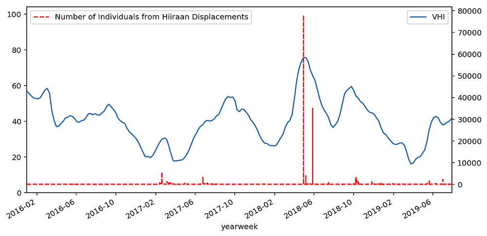
Hiiraan province: VHI (blue) versus flood-driven displacement counts (red dashed), 2016–2019. The June 2018 flood spike coincides with peak displacement. Image Source: Omdena
Before the project, the client’s Somalia operations relied entirely on reactive displacement data — counts reported from the field after movements had already occurred. The system inverted this sequence. By forecasting VHI one week ahead and mapping vegetation anomalies continuously, field teams could identify provinces entering drought stress before displacement peaked and pre-position resources during the preparation window.
The province-level correlation analysis resolved a question the client had no prior evidence to answer: displacement drivers differ systematically by region. Banadir, the province containing Mogadishu, recorded the highest arrival volumes, with most of those arrivals departing from Shabeellaha Hoose due to drought and conflict.
Hiiraan flood events and Sool drought onsets require different preparedness windows and resource volumes. The analysis gave the client a principled basis for calibrating alert thresholds by province rather than applying a single national trigger.
Benefits for Clients
A data-driven early warning instrument: The system combined satellite imagery, 40 years of climate records, and displacement data into a single predictive framework. For the first time, the client could query a one-week VHI forecast and a conflict zone classification alongside weekly displacement records in one codebase, rather than waiting for separate manual field reports.
No satellite science expertise required to interpret outputs: Change detection maps and VHI forecasts were structured to be readable by humanitarian operations staff without data science backgrounds. Province-level outputs aligned directly with the client’s existing operational geography, requiring no translation between model output and field planning decisions.
Open-source codebase via OmdenaLore: The full pipeline (satellite ingestion, PCA + K-Means anomaly detection, VHI neural network, and SVM/RF classifiers) is published on OmdenaLore, Omdena’s open-source knowledge-sharing platform. The client can audit, extend, or redeploy the system against updated satellite feeds or in other displacement-affected countries without vendor dependency or licensing costs.
What Building the Somalia Early Warning System Taught Us
When labeled training data is insufficient, unsupervised methods can still produce operationally useful change maps
The team’s first CNN+LSTM architecture for vegetation change detection required more labeled examples than Somalia’s historical satellite record provided. Switching to PCA + K-Means unsupervised clustering removed the label dependency entirely. The resulting change maps required no ground truth annotation and will apply equally to future provinces or countries where annotated satellite data does not exist.
Province-level displacement drivers are heterogeneous and must be modeled separately
Treating Somalia as a single prediction unit masked important regional patterns. Correlating VHI and displacement data at the province level revealed that Shabeellaha Hoose, Hiiraan, and Sool had distinct dominant hazard types: conflict, flood, and drought respectively. A national-level model would have averaged these signals out and produced alert thresholds too coarse to trigger a useful operational response.
Climate index and displacement records must be aligned in time before correlation analysis can be trusted
Both the NOAA VHI archive and the UNHCR displacement dataset arrived as weekly aggregates, but with different reference periods and implicit lag assumptions. Early correlation analyses returned weak or spurious links until the team aligned the two series correctly, accounting for the typical delay between VHI deterioration and population departure.
What’s Next
Real-time satellite feed integration: The current pipeline processes historical satellite scenes. Connecting it to live Landsat and MODIS feeds from EarthExplorer would allow change detection maps to update weekly, extending the early warning function from retrospective validation to continuous operational monitoring.
Deployment to other displacement-affected countries: The architecture applies to any country with NOAA VHI records and displacement tracking. Ethiopia, South Sudan, and the Sahel face comparable multi-hazard dynamics and analogous data profiles.
Integration with humanitarian logistics planning: The province-level displacement forecasts could feed directly into supply chain and staffing pre-positioning models, translating a predicted VHI decline into an estimated displacement volume and triggering a preparedness checklist before the event peaks in field reporting.
Key Achievements
Dual 99% Accurate Classifiers: Satellite Land Cover and Conflict Zone Detection
Two classifier workstreams each reached 99% accuracy from different angles. The Random Forest analyzed Landsat 8 imagery of the Banadir region to document how conflict and population movement altered land cover over time, showing increased urban density in Mogadishu as arrivals from drought- and conflict-affected provinces accumulated.
The SVM identified high-fatality violence zones from armed conflict event records, mapping where armed incidents were most severe. Together, the classifiers gave the client both satellite-grounded environmental evidence and conflict-event evidence for displacement planning.
What makes the VHI forecaster operationally significant is the depth of signal it learned from. Forty years of freely published NOAA/NESDIS weekly records gave the model a training window that no field-collected dataset could have matched. It achieves a validation loss of 0.030 and generates province-level forecasts at effectively zero ongoing data cost, since the VHI archive is updated publicly each week.
Unsupervised Satellite Pipeline Requiring No Labeled Ground Truth
The PCA + K-Means change detection pipeline was designed to operate without labeled training data. In humanitarian data environments, labeled ground truth for vegetation anomalies rarely exists at the scale needed for early warning. The pipeline can be pointed at any satellite scene pair and return a change map without annotation effort from field staff, lowering the barrier for future deployment to under-resourced country operations.
About the Project
Omdena partnered with the UN Refugee Agency to build a climate-displacement early warning system for Somalia. A team of 34 AI experts and data scientists integrated Landsat and MODIS satellite imagery, NOAA/NESDIS vegetation health records, and the client’s weekly displacement records to develop unsupervised change detection, neural network VHI forecasting, and conflict zone classification models. The full codebase is available on OmdenaLore and GitHub.
FAQ
What data sources did the system use?
Three sources: NOAA/NESDIS VHI records (weekly since 1984), Landsat and MODIS satellite imagery from EarthExplorer, and the client's weekly displacement records by Somali province since 2016. All three are openly available, keeping the system replicable without proprietary data agreements.
Why did the team choose PCA + K-Means instead of deep learning for satellite analysis?
CNN+LSTM required more labeled training data than Somalia's historical satellite record could provide. PCA + K-Means required no ground truth annotation, removed the label dependency entirely, and made the pipeline portable to any country without prior annotation effort.
Is the system deployed and in operational use?
The project delivered a validated research prototype and open-source codebase, not a production deployment. Operational use would require connecting the pipeline to live satellite feeds and a formal handoff to the client's field information systems.
What do the province-level displacement correlations mean for field operations?
Shabeellaha Hoose is conflict-dominated, Hiiraan flood-dominated, and Sool drought-dominated, with each distinction confirmed by correlating weekly displacement records with VHI and satellite change data at the province level. Each requires a different early warning trigger and preparedness window rather than a single national alert threshold.
How is the codebase made available?
The codebase is published on OmdenaLore, Omdena's open-source knowledge-sharing platform, and on GitHub at calincan2000/Omdena-UNHCR-Challenge, with documentation for running the pipeline against updated satellite feeds. No proprietary data agreements are required, since all three source datasets are openly available.
Share this article
Share on LinkedIn, send by email, or copy the direct link.