Fall Armyworm Detection from Satellite Imagery: Classifying Crop Damage at 94% Accuracy
10 min read
Omdena
Fall armyworm reached 70+ countries after arriving in Africa in 2016; traditional field scouting in Mali was too slow to catch infestations before yield loss. Omdena partnered with OKO Finance to build a satellite-based pest detection pipeline on Sentinel-2 and Landsat-8 imagery. Delivered: a ResNet50 model at 94% classification accuracy, a four-class damage assessment system, and a FastAPI inference API with Streamlit dashboard.
Key Outcomes
Outcome
Detail
Classification accuracy
94% (ResNet50 deep learning model)
Damage area prediction
0.39 RMSE (field-level area estimate)
Satellite images analyzed
2,000+ Sentinel-2 and Landsat-8 images
Infestation categories
4 severity levels: Zero, Low, Medium, High
Project duration
10 weeks, June–August 2021
Active collaborators
30
Final deliverable
FastAPI inference API + Streamlit dashboard + Docker container
The Problem: Detecting Fall Armyworm Outbreaks Before Crop Losses Become Irreversible
The fall armyworm (Spodoptera frugiperda) arrived in Africa in 2016 and spread to more than 70 countries within five years. In Mali and neighboring West African nations, it attacks maize—the staple crop for millions of smallholder farmers—sometimes devastating entire fields before detection. Early identification of infestation severity is essential for reducing yield losses and enabling timely, targeted interventions.
Traditional detection relies on trained scouts inspecting fields on foot. The process is labor-intensive, expensive, and too slow. By the time an infestation was confirmed and intervention materials reached affected farmers, the damage was often irreversible. For OKO Finance, accurate and timely damage data was foundational to pricing risk and processing claims fairly.
The Partnership: Omdena and OKO Finance
Omdena partnered with OKO Finance, a West African crop microinsurance company that designs insurance products for smallholder farmers across Mali and neighboring countries. The client needed a data-driven method to understand where and how severely fall armyworm was striking before policyholders filed claims, a capability that did not exist in its operational toolkit.
Thirty collaborators from the Omdena network contributed to the ten-week project, which ran from June to August 2021. The team combined expertise in remote sensing, computer vision, geospatial analysis, and machine learning to build a proof-of-concept detection pipeline grounded in publicly available satellite imagery and open-source field data.
Why Fall Armyworm Detection Is Hard: Unreliable Ground Truth, Class Imbalance, and Spectral Ambiguity
Unreliable ground truth data: The FAO fall armyworm scouting initiative provided geolocation and severity records, but cross-verification with experts at Penn State University’s PlantVillage project confirmed that more than 60% of the records contained inaccurate coordinates, frequently pointing to urban areas rather than maize fields. Models trained on mislabeled data cannot learn reliable patterns.
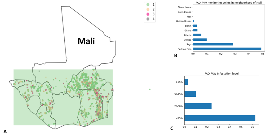
Severe class imbalance: Roughly 60% of FAO records showed infestation below 25%, and only about 5% showed the highest severity level. Models trained on this distribution consistently learned to predict the majority class and failed on the rare high-infestation cases that matter most for insurance assessments, requiring deliberate rebalancing strategies throughout the project.
Spectral ambiguity: Fall armyworm damage changes vegetation reflectance, but so do drought, disease, and soil variation. Distinguishing pest damage from other crop stressors using multispectral vegetation indices creates an uncertain signal; without confirmed ground-truth photographs for every location, the available data directly constrains what any model can achieve.
FAO fall armyworm monitoring points across Mali and neighboring countries (A), distribution by country (B), and infestation severity distribution showing ~65% of records below 25% (C). Image Source: Omdena.
Building the Fall Armyworm Detection Pipeline: Satellite Imagery, Vegetation Indices, and Deep Learning
Step 1 — Data Collection
The team assembled training data from six sources: Sentinel-2 and Landsat-8 for multispectral imagery, FAO fall armyworm scouting records for infestation labels, Radiant ML Hub’s 2018 African landcover dataset, administrative boundaries for geolocation filtering, and LULC grids to retain only high-vegetation areas.
Step 2 — Preprocessing and Vegetation Index Extraction
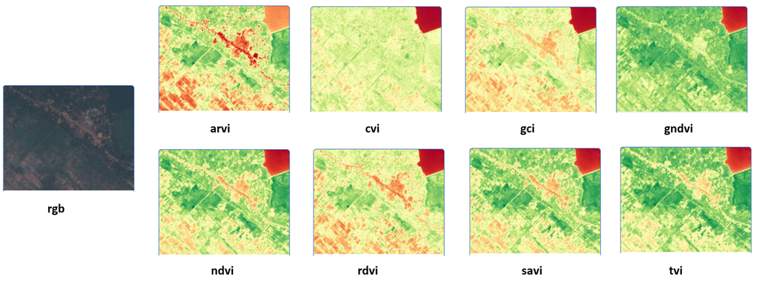
Eight vegetation indices were extracted from the red, green, blue, and near-infrared bands: NDVI, GNDVI, RDVI, CVI, GCI, SAVI, TVI, and ARVI. SMOTE (synthetic minority oversampling technique) addressed the class imbalance. K-means clustering removed FAO geolocation outliers by filtering records more than 3 kilometers from administrative boundaries, retaining only village and hamlet locations with confirmed vegetation coverage.
RGB satellite tile (left) and all eight vegetation indices extracted for a sample West African field location. Image Souce: Omdena.
Step 3 — Model Training
The team evaluated five ML classifiers—KNN, random forest, SVM, logistic regression, and decision tree—alongside ResNet50, EfficientNet, InceptionV3, and U-Net. KNN with n=2 neighbors reached 56% test accuracy. ResNet50 required two data collection rounds: an initial run on 5,000 images yielded 47%; a second round using 1,040 larger images tiled into 26,000 patches pushed accuracy to 94%, with 0.39 RMSE on damage area estimation.
Step 4 — Damage Classification
The final classification system assigned each field location to one of four severity categories: Zero infestation (no damage), Low (0–20% field area affected), Medium (20–50% affected), and High (50–100% affected). The ResNet50 model received three stacked vegetation-index channels—GCI, NDVI, and SAVI—as input and produced both a class label and a continuous area estimate in a single forward pass.
Step 5 — Inference API
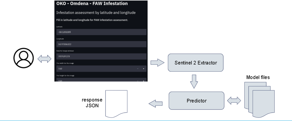
The complete pipeline was deployed as a FastAPI service accessible via REST. A Streamlit web application let users enter a location and date, then view vegetation indices and an infestation severity prediction returned as a JSON response. The full system was containerized with Docker for independent deployment.
What Was Delivered: A Satellite-Based Fall Armyworm Inference Service
The inference service: Streamlit input form (left), Sentinel-2 data retrieval and model prediction flow, and JSON response output. Image Source: Omdena.
ResNet50 classification and area prediction model: The best-performing model classified infestation severity at 94% accuracy and estimated the fraction of field area damaged with an RMSE of 0.39. It accepted three stacked vegetation-index images as input and produced both a class label and a continuous damage estimate in a single forward pass.
FastAPI inference API: The REST service accepted latitude, longitude, and a date, automatically queried Sentinel-2, ran the selected model, and returned a JSON response with vegetation index values and predicted infestation level; no specialist remote sensing knowledge was required.
Streamlit web dashboard: A Streamlit interface enabled non-technical users to query the system by entering coordinates and a date, with results displayed inline, accessible to field staff without programming experience.
Docker container: The pipeline was containerized with Docker and documented with README files covering installation, data requirements, and API usage, enabling the client to deploy and maintain the system independently.
Impact: Proof of Concept for Satellite-Based Pest Monitoring in West Africa
Before this project, the client had no scalable, automated method for detecting fall armyworm infestations or assessing crop damage levels without deploying field scouts. The delivered system provided a first operational proof of concept: a pipeline that takes a geographic coordinate and a date, queries publicly available satellite data, and returns a damage severity estimate, with no ground-level access required.
The more consequential finding emerged from data validation rather than modeling: the FAO scouting dataset, widely used as ground truth in fall armyworm research, had a data-quality problem severe enough to compromise any model trained on it without filtering, corroborated by expert review from PlantVillage at Penn State University, and relevant to any team working on satellite-based pest monitoring in West Africa.
Benefits for the Client
A first quantitative instrument for pest damage assessment: The client gained a working end-to-end pipeline that could estimate fall armyworm infestation severity from satellite coordinates and dates, providing a data layer for insurance risk modeling that did not previously exist.
No specialist remote sensing expertise required: The Streamlit dashboard and FastAPI interface abstracted the satellite data retrieval and model inference entirely, allowing field staff and analysts to query the system by entering a location and date, with no programming or geospatial skills needed.
Open-source codebase via OmdenaLore: All models, preprocessing scripts, and API code were released through OmdenaLore, Omdena’s open-source knowledge-sharing platform, giving the client a fully auditable codebase with no commercial licensing dependencies and the ability to extend or adapt the system as data quality improves.
What Building a Satellite-Based Pest Detection System Taught Us
Ground-truth errors introduced at collection cannot be corrected at training time
FAO geolocations pointed to urban areas in more than 60% of cases, rendering those records unusable as training labels. Filtering by administrative boundaries and LULC vegetation grids reduced the dataset but improved reliability; without that step, every model trained would have been learning from noise.
A four-class system is only as reliable as the minority classes in training data
The highest-infestation category represented only 5% of the dataset, and every model struggled to detect it. SMOTE improved the class balance, but synthesized samples cannot substitute for real high-severity observations. Future deployments will require a deliberate strategy to collect geolocated, photographically confirmed high-infestation records.
Proof of concept and production readiness are separated by data quality, not algorithm choice
ResNet50 reached 94% accuracy in controlled evaluation, but that figure reflects a filtered and partially synthesized dataset, not live unvalidated satellite imagery. Moving to production will require verified ground-truth photographs paired with satellite acquisitions before accuracy can be claimed at operational scale.
What’s Next: Verified Field Data, Longer Time Series, and Broader Coverage
Verified ground-truth collection: A structured field-data campaign pairing confirmed infestation photographs with GPS coordinates and acquisition dates is the most critical next step. Even a few hundred verified records would significantly outperform thousands of unverified FAO records as a training foundation.
Extended time series: Longer image sequences spanning full growing seasons across multiple years would allow models to separate pest damage from drought, crop-stage variation, and other stressors, the core spectral ambiguity that limits current accuracy.
Wider geographic coverage: Expanding to Burkina Faso, Côte d’Ivoire, and Uganda, all countries with active fall armyworm pressure and established crop insurance programs, would increase the system’s reach and generate more diverse training data.
Key Achievements
A Five-Stage Detection Pipeline from Satellite Data to Damage Estimate
The team built and delivered a complete sequential pipeline: satellite image collection, automated vegetation-index extraction across eight spectral indices, model training across machine learning and deep learning architectures, four-class damage severity classification, and a containerized inference API, end-to-end with no manual steps between coordinate input and severity prediction.
ResNet50 Model at 94% Classification Accuracy with Dual Output
ResNet50 combined infestation classification and damage area estimation in a single forward pass, a dual-output architecture no simpler model could replicate. Stacking GCI, NDVI, and SAVI as three input channels extracted feature representations that scalar vegetation-index values alone could not capture, demonstrating the value of deep convolutional architectures for agricultural remote sensing.
Open Documentation of a Critical Ground-Truth Data Quality Problem
By verifying FAO scouting coordinates against administrative boundaries and LULC vegetation maps, and confirming the problem with PlantVillage domain experts, the team documented that the most widely used fall armyworm ground-truth dataset in West Africa was majority-unreliable, alerting future teams to apply the same filtering steps before training.
About the Project
Omdena partnered with OKO Finance over ten weeks in 2021 to build a satellite-based fall armyworm detection pipeline for southern Mali. Thirty collaborators analyzed 2,000+ Sentinel-2 and Landsat-8 images, trained machine learning and deep learning models for four-class damage classification, and delivered a FastAPI inference API, a Streamlit dashboard, and a Docker container as the final output.
FAQ
What satellite data sources were used in this project?
Sentinel-2 and Landsat-8 multispectral imagery, both freely available. Sentinel-2 provided the primary training images; Landsat-8 contributed longer time-series data to capture seasonal vegetation variation.
Why was the FAO scouting dataset unreliable, and how was that addressed?
More than 60% of FAO geolocations pointed to urban areas rather than fields, confirmed by PlantVillage experts at Penn State. Records were filtered by administrative boundaries and LULC vegetation grids to retain only village-level, high-vegetation locations.
Is the system ready for production deployment?
No. The project delivered a proof of concept. The 94% accuracy figure reflects a filtered and partially synthesized dataset; reliable production use will require substantially more verified ground-truth data paired with satellite acquisitions.
How does the inference API work?
A user submits coordinates and a date; the system queries Sentinel-2, extracts vegetation indices, runs the model, and returns a JSON response with the predicted infestation severity level.
What were the four damage categories used?
Zero, Low (0–20%), Medium (20–50%), and High (50–100%) field area affected, chosen to balance class representation while remaining meaningful for insurance assessments.
Share this article
Share on LinkedIn, send by email, or copy the direct link.