Humanitarian Infrastructure Mapping: Road and Rooftop Classification at 99.27% Accuracy
9 min read
Omdena
Road passability and building vulnerability are critical unknowns in disaster response, typically unavailable when logistics decisions must be made. Omdena partnered with a humanitarian mapping organization to build a road surface classifier and a rooftop material segmenter from field and aerial imagery. The project delivered a Swin Transformer with 99.27% accuracy for road classification and two segmentation models for five rooftop material classes, both open source.
Key Outcomes
Outcome
Detail
Road classification accuracy
99.27% — Swin Transformer on paved vs. unpaved road imagery
Inference speed
~0.12 seconds per image, enabling batch processing of large field imagery volumes
Training dataset
1,202 images — Kenya + India; balanced 49% paved / 51% unpaved across diverse seasonal and terrain conditions
Rooftop segmentation
5 classes — UNetCA: Mean IoU 0.9213, Mean Dice 0.9485 | SegFormer-B3: Mean IoU 0.9126, Mean Dice 0.9511
Unified YAML-configurable launcher; weights publicly hosted; local and cloud inference supported
The Problem: Infrastructure Blind Spots That Delay Humanitarian Aid
When a cyclone or flood strikes, humanitarian logistics teams need to know not what to send but where vehicles can go. Road condition data in disaster-affected areas is frequently outdated or absent in usable formats. Acting on inaccurate passability assumptions wastes time and can leave communities cut off from essential supplies.
Rooftop materials signal building vulnerability to flooding and wind damage, but getting that information requires new satellite imagery or survey teams — neither is possible in the first hours after a disaster. Existing AI tools also broke down outside the regions where they were trained, and road and building analysis ran as separate systems that field teams had to combine manually.
The Partnership: Omdena and a Humanitarian Mapping Organization
Omdena partnered with a humanitarian mapping organization to build AI tools for road condition and rooftop material analysis. Three field requirements guided the work: outputs loadable into standard mapping tools, reliable performance on low-quality imagery, and a setup simple enough for organizations with no dedicated AI team.
Why Geospatial Infrastructure Analysis from Street-Level Imagery Is Hard
Training data from one region will fail in another: A road dataset covering only Kenyan imagery performed well locally but failed in new regions. Expanding to Indian imagery with rain, dry-season, and varied terrain (including waterlogged roads and partially paved paths) allowed the model to generalize reliably across geographies.
When one class dominates the data, models learn to ignore the rest: Both datasets were imbalanced — road images favored unpaved surfaces, and rooftop images had far more zinc and tile examples than wood or plastic. Adjusted loss functions and sampling were needed to achieve fair performance across all categories.
Duplicate images make results look better than they are: Street-level frames captured seconds apart look nearly identical, inflating scores without improving real-world performance. Rooftop annotations also had geometry mismatches, with label outlines misaligned to actual roof boundaries, requiring manual correction before training could begin.
Overlapping rooftops confuse models even when the data is good: Where buildings sit close together, rooftop edges blend in ways that make it hard for models to separate structures. Even SegFormer-B3 struggled here, requiring changes to model architecture rather than simply adding more training data.
Building the Street Imagery Analysis System: Computer Vision Pipelines and Deployment
The build ran across three phases: road surface classification, rooftop segmentation, and unified pipeline deployment. Each required its own data preparation, model selection, and evaluation before integration into a single deployable system.
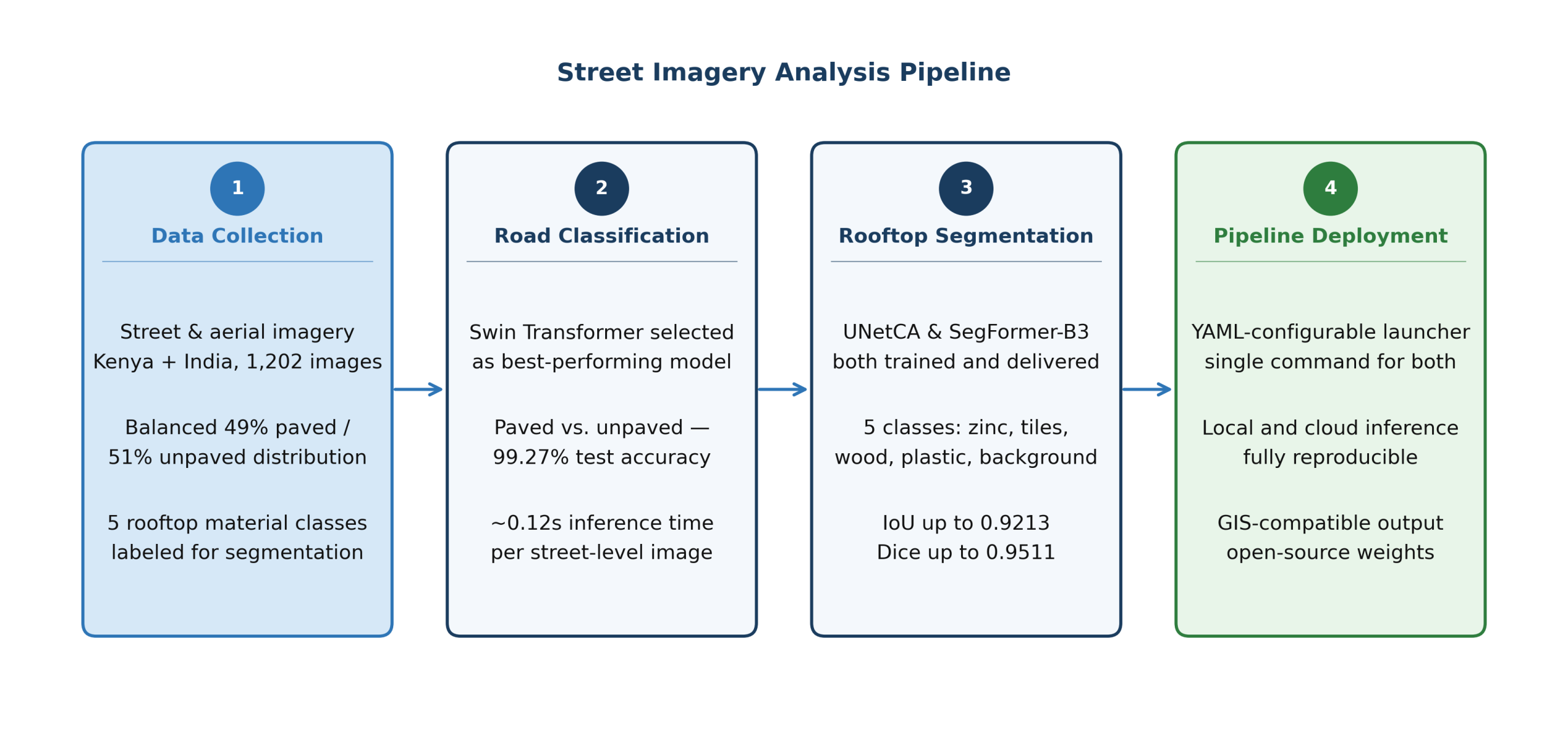
Figure 1: Street imagery analysis pipeline: from data collection through road classification, rooftop segmentation, and field deployment via unified inference pipeline
Phase 1: Road Surface Classification
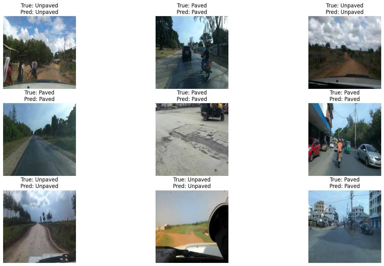
The road classification pipeline used a 1,202-image dataset combining 759 Kenyan images sourced via the Mapillary API with 443 from India, covering rain, dry-season, and varied terrain including waterlogged roads and vegetation-obstructed surfaces. Three architectures were tested (EfficientNet-B0, MobileNetV2, and the Swin Transformer), with the Swin Transformer selected for its ability to capture image detail across multiple scales.
Fine-tuned over 10 training rounds using PyTorch and Hugging Face Transformers on an NVIDIA RTX 3050, the Swin Transformer reached 99.27% accuracy on the test set with approximately 0.12 seconds per image, making it practical for batch processing large field imagery volumes in post-disaster mapping workflows.
Phase 2: Rooftop Material Segmentation
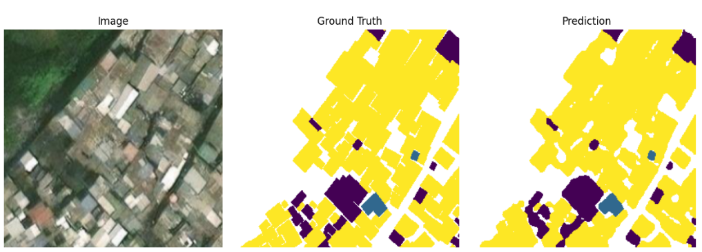
Aerial imagery from the Ghana RIA project was labeled across five classes (background, zinc, tiles, wood, and plastic) and resized to 256×256 pixels, with all preprocessing built into the pipeline. Two architectures were compared: UNetCA, which integrates channel attention to enhance spatial awareness in feature maps, and SegFormer-B3, pre-trained on ADE20K and suited to densely built areas with overlapping structures.
UNetCA produced a stronger Mean IoU of 0.9213; SegFormer-B3 achieved a higher Mean Dice of 0.9511. Both were delivered, giving practitioners a concrete choice based on whether region accuracy or boundary overlap is the operational priority.
Figure 3: Rooftop material segmentation: aerial image, ground truth mask, and model prediction (UNetCA)
Phase 3: Unified Pipeline Deployment
A YAML-configurable launcher serves inference for both pipelines through a single command. Users specify the model, mode, and settings file with no code changes required to switch between architectures or regions. Weights, logs, and outputs are saved automatically, supporting full reproducibility on local and cloud environments.
What Was Delivered: Road Classifier, Rooftop Segmenter, and Unified Pipeline
Road surface classifier: A Swin Transformer model that classifies street-level images as paved or unpaved at 99.27% accuracy and ~0.12 seconds per image. Trained weights are publicly hosted and compatible with batch processing pipelines for large field imagery volumes.
Rooftop material segmenter: Two trained segmentation models, UNetCA (Mean IoU 0.9213) and SegFormer-B3 (Mean Dice 0.9511), for classifying five rooftop material categories from aerial imagery. Practitioners can select based on whether boundary overlap or region accuracy is the operational priority.
Unified YAML-configurable inference pipeline: A single launcher script runs training or inference for any configured model with one command. Users switch between architectures and datasets via config file alone, with no code changes required. Supports local and cloud deployment; all results are saved automatically.
Impact: Geospatial Intelligence That Aid Teams Could Not Access Before
Street-level imagery already held by field teams can be assessed for road passability at 0.12 seconds per image, removing the dependency on field access that previously delayed logistics planning after a disaster.
Rooftop material classification from existing aerial imagery gives planners shelter vulnerability data without commissioning new surveys. Buildings with zinc or wood roofing indicate different risk levels than tile construction, a distinction that directly informs shelter prioritization.
The unified launcher removed the step that previously forced specialists to combine results from separate tools by hand. A single command now returns both road and rooftop assessments, and extending to a new region or imagery type requires only a settings file change.
Benefits for Clients: Speed, Coverage, and a Deployable Open Pipeline
Automated infrastructure assessment from existing imagery: Road condition and building material assessments run from imagery that field teams already hold, with no new satellite order or survey team required. Results are ready in minutes, removing the data gap that slows logistics decisions in the critical hours after a disaster.
No AI expertise required to operate: Field engineers and mapping analysts run the system with a single command and a settings file, with no model code or technical adjustments needed. All results are saved automatically, making it accessible to organizations with no dedicated AI team.
Open pipeline via OmdenaLore: The full pipeline — training configuration, model weights, preprocessing logic, and documentation — is available through OmdenaLore, Omdena’s open-source knowledge-sharing platform. Any humanitarian organization can fork, adapt, and retrain it for their own geographic coverage or material classification needs at no cost.
What Building an AI Infrastructure Analysis System for Humanitarian Response Taught Us
Training in one place does not prepare a model for everywhere else
The initial road dataset worked on Kenyan imagery and failed elsewhere. Adding Indian imagery with rain, dry-season, and varied terrain improved cross-region accuracy more than adding more images from the same location would have, making breadth of training data more valuable than adding more of the same.
Delivering two models instead of one gives teams a real choice
Neither UNetCA nor SegFormer-B3 dominated every metric: SegFormer achieved a higher Dice score while UNetCA produced stronger mean IoU. Delivering both gave practitioners a real choice based on operational priority — boundary accuracy or region overlap — rather than a single prescribed answer.
Building it configurable from the start saves weeks of rework later
A settings-driven launcher built early let the team swap models, adjust data settings, and test ideas without rewriting code. For a tool supporting multiple models, regions, and use cases over time, that configurability is what makes it practical to maintain and extend.
What’s Next
Expanded geographic coverage: Adding labeled imagery from Southeast Asia, Latin America, and the Middle East would extend road classifier reliability beyond Kenya and India without retraining from scratch.
“Likely impassable” road detector: A specialized classifier that goes beyond the paved/unpaved binary to identify roads blocked by flooding, debris, or surface degradation would provide more precise passability assessments for logistics planning.
Key Achievements
A Road Surface Classifier Validated Across Geographies at 99.27% Accuracy
The road surface classifier was validated across geographically diverse Kenyan and Indian imagery, reaching 99.27% accuracy and 0.12 seconds per image. That combination of precision and speed means the tool performs under post-disaster logistics constraints, not only in controlled evaluations.
A Dual-Architecture Rooftop Segmentation System for Five Material Classes
UNetCA’s stronger mean IoU serves tasks where boundary precision matters; SegFormer-B3’s higher Dice coefficient suits region-level classification. Delivering both gave practitioners a decision based on field priority rather than a single prescribed answer.
A Unified Pipeline That Eliminates the Workflow Gap Between Road and Building Analysis
Before this system, getting road and rooftop results together meant running separate tools and combining outputs by hand. A single launcher command now runs both models at once, removing a step that cost time at exactly the moment humanitarian teams can least afford delay.
About the Project
Omdena partnered with a humanitarian mapping organization to build AI tools for road surface classification and rooftop segmentation from street-level and aerial imagery. Deliverables include a Swin Transformer road classifier at 99.27% accuracy, two rooftop segmentation models across five material classes, and a unified YAML-configurable inference pipeline, all fully open-source.
FAQ
What does the road surface classifier actually produce?
It classifies each street-level image as paved or unpaved at 99.27% accuracy and ~0.12 seconds per image. Outputs are saved automatically and feed directly into logistics and routing workflows.
What rooftop materials can the segmentation system identify?
Five categories: zinc, tiles, wood, plastic, and background, selected from the Ghana RIA dataset to reflect material types most relevant to shelter vulnerability assessments.
Which rooftop model should an organization use — UNetCA or SegFormer-B3?
Use SegFormer-B3 (Dice 0.9511) when region accuracy is the priority; use UNetCA (IoU 0.9213) when boundary precision matters more. Both are delivered; the choice is operational.
Can the system work in areas without reliable internet connectivity?
Yes: the pipeline supports fully local deployment with pre-loaded model weights. All preprocessing and inference run within the launcher, with no cloud dependency.
Can the pipeline be adapted for tasks beyond road and rooftop analysis?
Yes: adapting requires new training data and a config file. The pipeline structure, preprocessing logic, and inference runner transfer directly without rebuilding from scratch.
Share this article
Share on LinkedIn, send by email, or copy the direct link.