
How Agribusinesses Are Using AI to Beat Extreme Weather Risk
84% forecast accuracy vs 47% for standard models. See 5 AI applications protecting agribusiness yields, real ROI data and a 5-step roadmap to start.
April 24, 2026
10 minutes read
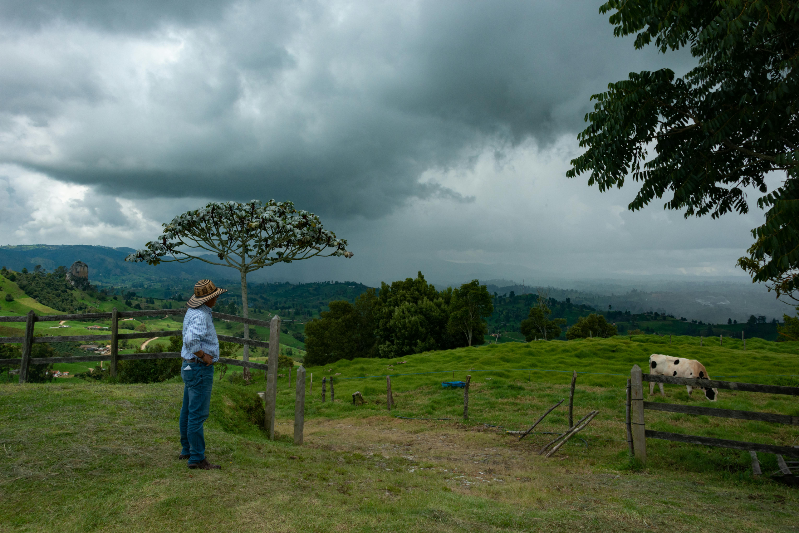
Climate-related agricultural losses now exceed $120 billion annually, according to the Food and Agriculture Organization of the United Nations. For agribusinesses managing tight margins across drought, frost, flooding, and unpredictable pest pressure, the question is no longer whether climate risk is real. It is whether you are seeing it early enough to act.
Predictive weather modelling, satellite crop monitoring, AI-driven risk assessment: capabilities once available only to large commodity traders and government agricultural bodies are now being deployed by agribusinesses running 50 to 500 acres across Sub-Saharan Africa, South Asia, Southeast Asia, and Latin America, without in-house data teams. The barrier is not budget or scale. It is knowing which tools apply to your specific operation and how to configure them to catch the events that cost you the most.
This article covers five AI applications protecting agribusiness yields right now, what real deployments are returning in measurable terms, and how to start regardless of your current data infrastructure.
What AI Actually Does for Climate Risk
AI does not eliminate climate risk. What it does is compress the time between a weather event forming and your ability to respond to it. That window, from the moment a risk signal appears to the point where you can still act on it, is where most agribusiness losses are decided.
The technology works across four layers: forecasting predicts incoming risk 7 to 14 days out, satellite monitoring tracks current field conditions, early warning flags pest or disease pressure before it is visible on the ground, and risk modelling quantifies seasonal exposure for insurance and procurement decisions.
Each of these layers is accessible to agribusinesses without dedicated data teams. The technology is only half the equation. The other half is configuration: knowing which signals matter for your specific crop, geography, and decision cycle. Getting that right is the difference between an AI tool that pays for itself and one that sits unused after the first season.
5 AI Applications Protecting Agribusinesses’ Yields Right Now
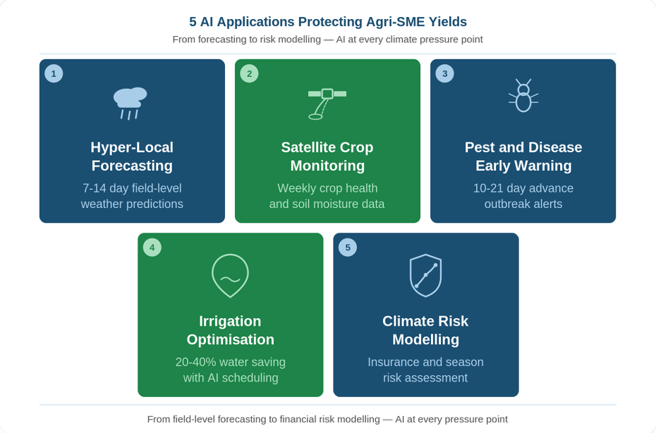
5 AI Applications Protecting Agri-SME Yields Right Now
1. Hyper-Local Weather Forecasting
AI-powered tropical weather forecasting deployed across West African agribusiness networks has delivered 84 percent accuracy in rainfall prediction, compared to 47 percent for conventional regional models. That gap translates directly into better planting windows, more precise irrigation scheduling, and fewer mistimed field operations.
Hyper-local forecasting delivers field-level predictions 7 to 14 days out, accounting for microclimatic variation that regional models miss entirely, and improves with each season of accumulated local data. In low-connectivity regions, forecasts arrive via daily SMS with no smartphone, internet connection, or hardware investment required, making this the most practical entry point for agribusinesses in emerging markets.
2. Satellite-Based Crop and Soil Monitoring
Farms using satellite-based crop monitoring have reduced reactive input spending by up to 20 percent by detecting crop stress early enough to intervene before it becomes visible damage or escalates into full crop loss.
Satellite imagery tracks NDVI (a measure of vegetation health) and soil moisture levels to deliver a weekly read on field conditions without any on-farm sensors or hardware. Coverage follows satellite orbit rather than internet infrastructure, making it equally accessible for remote and fragmented plots. For agribusinesses with limited ground-based data, each season of monitoring builds a performance record that becomes the foundation for every subsequent AI layer: forecasting, early warning, and risk modelling.
3. Pest and Disease Early Warning Systems
AI pest early warning systems are cutting reactive spray costs by 15 to 25 percent by giving agribusinesses a 10 to 21 day lead on outbreaks that traditional calendar-based spray schedules consistently miss.
Models trained on climate patterns, historical outbreak records, and crop vulnerability data flag elevated risk before it is visible in the field, giving agribusinesses time to intervene precisely rather than spray reactively across the entire crop. The signals also improve each season: as the model accumulates local data, accuracy becomes more specific to your crop and geography, reducing both false alarms and missed events.
4. Irrigation and Water Optimisation
Agribusinesses using AI irrigation management are consistently reporting water savings of 20 to 40 percent with no reduction in yield. That is a direct margin gain during drought periods or in regions where water costs are rising.
These tools combine soil sensor data, hyper-local weather forecasts, and evapotranspiration models to calculate exactly when and how much to irrigate, then output a simple daily schedule your team can act on without technical expertise or agronomic support. For operations managing water as a constrained resource, this is consistently one of the highest-returning AI applications available, with savings verifiable within a single season.
5. Climate Risk and Crop Insurance Modelling
AI climate risk modelling is helping agribusinesses reduce insurance costs and contingency budget waste by quantifying their actual seasonal exposure before each planting cycle, replacing the guesswork that leads to both underinsurance and overexposure.
These models analyse historical weather patterns, crop vulnerability data, and farm-level inputs to produce a risk profile covering insurance selection, replanting budgets, and capital allocation. Some insurers now accept AI-verified risk assessments as part of underwriting, reducing premiums for operations with demonstrably lower exposure. For agribusinesses with significant seasonal exposure, the compounding benefit of better risk decisions year after year is where the real financial leverage sits. AI weather forecasting in tropical regions is hitting 84 percent accuracy. Most agribusinesses are still planting on last year’s calendar.
Real Deployments, Real Results — Omdena
Togo: Zone-Level Extreme Weather Forecasting to Protect Farmers and Crops
In Togo, an Omdena team built a machine learning system for extreme weather forecasting to address a clear problem: climate change was intensifying Togo’s rains and dry seasons while government alerts were failing to reach farming communities in time to act. Roads regularly flooded to waist height during heavy rains, cutting off market access; clean water for irrigation became critically constrained during dry periods.
The team built classification models predicting weather conditions by geographic zone — rain or drought, severity, and likely duration. Deployed as an API with a map-based web interface, the system triggers SMS and email alerts to affected farms when an extreme event is detected, with no smartphone or internet connection required.
For agribusinesses, the value is in the lead time. Knowing a 10-day drought is approaching changes irrigation and water storage decisions before the shortfall hits. Knowing heavy rains will affect a specific zone changes harvest timing, transport planning, and field operations. A calendar cannot provide that. A national weather average cannot provide that. A zone-level model built on local data can.
Zambia: Crop Yield Prediction for Small-Scale Farmers Using Local Weather Data
In Kitwe, Zambia, an 18-person Omdena team tackled a problem common across agribusiness markets globally: small-scale farmers planning their seasons on traditional methods that climate variability has made increasingly unreliable. Irregular rainfall and temperature extremes were leading to poor input allocation, mistimed planting, and consistent yield shortfalls.
The team built a regression model trained on local temperature, rainfall, and humidity data to predict crop yields before the season begins. Packaged as a web app and API, farmers enter their crop type and planting details and receive a yield forecast for their location. No agronomist, soil laboratory, or extension service is required.
For a small-scale agribusiness making input purchasing decisions weeks before planting, the difference between a weather-driven guess and a data-informed forecast changes the math. It changes how much seed to buy, how much labour to budget, and whether the season is worth financing at all.
The Cost and ROI Case: What Agribusinesses Are Actually Seeing
Agribusinesses using AI climate tools are reporting consistent returns across every major application area: weather forecasting improving yields 10 to 20 percent through better-timed decisions, AI irrigation cutting costs 25 to 40 percent, and pest early warning reducing reactive spray spend by 15 to 25 percent. These are field-season outcomes, not vendor projections.
| AI Application | What It Protects | Reported Saving | Source |
|---|---|---|---|
| Hyper-Local Forecasting | Input waste from mistimed planting and spraying decisions | 15 to 20% input cost reduction | Field deployments across West Africa |
| Satellite Monitoring | Reactive treatment costs from undetected crop stress | Up to 20% reduction in unplanned input spend | NASA Harvest / SatSure |
| AI Irrigation | Water and energy costs during drought or constrained supply | 20 to 40% water cost saving | Multi-region AI irrigation deployments |
| Pest Early Warning | Pesticide spend and crop losses from reactive treatment | 15 to 25% spray cost reduction | Plantix / CGIAR |
| Climate Risk Modelling | Insurance premium waste and seasonal contingency gaps | Reduced premium costs and improved margin protection | World Bank / CGIAR |
The more important calculation is the one most agribusinesses skip. ROI on climate AI is not measured against the monthly platform cost. It is measured against the cost of the event you did not see coming.
A single frost on a 200-acre orchard can represent $80,000 to $150,000 in protected revenue. One drought season without early warning can wipe 30 to 40 percent of annual margin. Against those numbers, the question is not the platform cost. It is whether the tool is configured to catch that event for your specific crop and location.
Off-the-shelf tools are built for broad geographies and average conditions, not your microclimate, crop mix, or seasonal risk windows. The operations reporting the strongest returns had a model built around their specific risk profile, crop data, and decision cycle. That is not a subscription. That is a capability.
How to Start: A 5-Step Climate AI Roadmap
Step 1: Identify Your Single Highest-Exposure Risk
Start by identifying the one climate event that has cost you the most in the past three seasons — a drought, a frost, a mistimed pest outbreak. That event becomes the brief for the first tool you evaluate. Most agribusinesses seeing strong ROI did not implement five tools at once. They fixed one problem first, measured the result, and expanded from there.
Step 2: Start Monitoring Before You Have Perfect Data
Most agribusinesses delay because they assume they need years of historical data first. They do not. Satellite monitoring works from day one with no sensors or prior data collection required. One season builds the baseline your next decisions run on. The only way to have last season’s data is to have started last season.
Step 3: Pick Tools That Match Your Team and Connectivity
Before committing to any platform, check two things: does it work without reliable internet, and does it deliver outputs your team can act on without a data analyst? The best tool is not the most sophisticated — it is the one your existing team will actually use. Forecasting delivers via SMS, monitoring via simple reports, irrigation as a daily water schedule rather than raw sensor data.
Step 4: Connect Outputs to Your Decision Cycle
Climate AI delivers its full value only when outputs feed directly into your planting calendar, input purchasing, and staffing schedules — this is the step most agribusinesses skip, and where most ROI is lost. Before deploying any tool, define what action each alert triggers: a frost warning changes your harvest window, a drought signal changes irrigation, a pest alert changes spray timing. That protocol converts data into decisions.
Step 5: Track One Metric and Build From There
After your first season, compare one metric against your previous baseline: input spend per acre, total water usage, yield per hectare, or reactive spray cost. That single comparison tells you whether the investment is working and whether to expand. Agribusinesses that measure systematically report consistently higher ROI than those who implement and assume.
The Path Forward: Turning Climate Intelligence Into a Competitive Advantage
The agribusinesses pulling ahead are not waiting for perfect conditions or perfect data. They are building the capability now, one application at a time, one season at a time. The results compound. A season of satellite monitoring becomes the training data for a more accurate early warning model. A season of hyper-local forecasting improves every planting and input decision the following year.
Climate AI is not a silver bullet, and it is not a one-size-fits-all platform. The operations seeing the strongest returns approached it as a custom problem. They mapped their specific exposure, chose the right entry point, and built their response around their own operation, not a generic template built for someone else’s geography and crop mix.
If you are at the stage where you know the risk is real but a generic dashboard is not giving you what your operation needs, the next step is a conversation built around your specific crops, geography, and seasonal risk windows, not a platform demo.
Omdena works with agribusinesses to design and deploy custom climate AI models built around your risk profile, your crop data, and your decision cycle. If you are ready to move beyond off-the-shelf tools, get in touch to start with a climate risk assessment tailored to your operation.